Travel by Any Means Necessary

Category: Hiking Page 3 of 5

Presque Isle Waterfalls

Manhabezo Falls

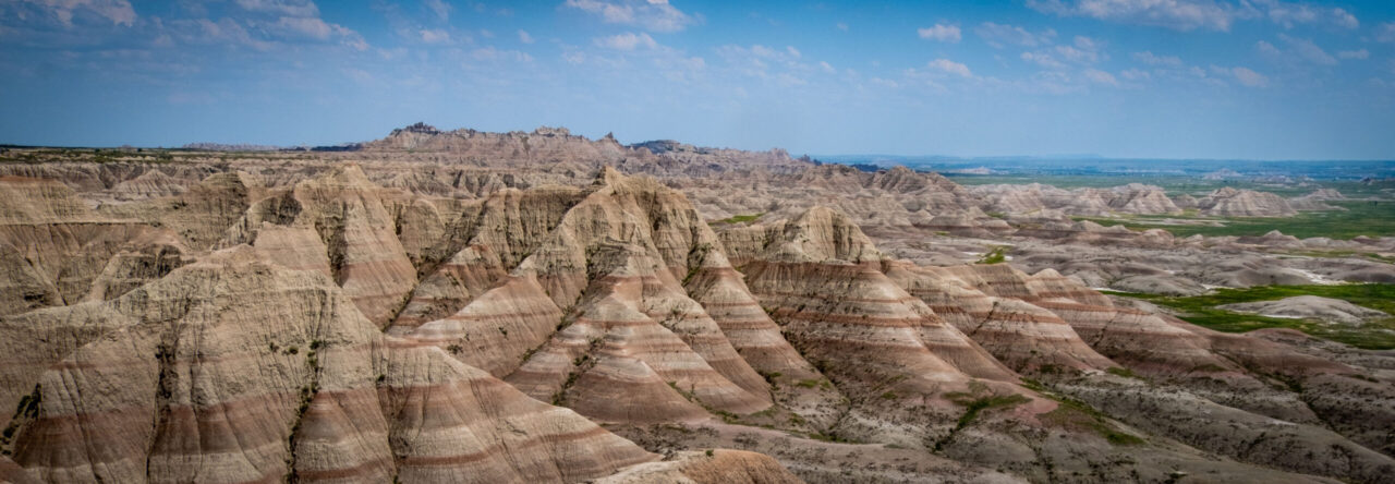
Located 25 miles from the Union Bay area, the Presque Isle area of Porcupine Mountains Wilderness State Park is like a whole different park. This section of the park is home to three waterfalls: Manabezho Falls, Manido Falls,  and Nawadaha Falls. A moderate hike of about two and a quarter miles will take you to these three falls.

These picturesque falls are all on the Presque Isle River and the water flows from up in the Porcupine Mountains and it wears down the rocky bedrock as it travels into Lake Superior. As in the case of what is known as “the potholes”, the swirling water has cut half circles out of the rock and is really interesting to watch from above on the rope bridge.

Manido Falls

My one complaint about the area is that with all the foliage, the various falls can be difficult to see from the observation areas. You can’t even really see Nawadaha Falls on the parking lot side of the river. There are signs all over telling you to stay on the path and if they really want people to do that, they should trim the trees that block the views from the platforms (see the large leaf in the above photo of Manido Falls). If people see the falls from the viewing areas, they are much less likely to go off the path and do something unsafe to get that photo.

When you get to the Presque Isle section of the park, there are a few different parking areas so you don’t have to hike the full 2.3 miles to see these waterfalls. There are three different parking areas and the one closest to the ranger station allows for ADA accessible viewing of Nawadaha falls. The rest of the falls do require some stair climbing to get to view. This is one of the most accessible parts of the Porcupine Mountains because you don’t have to climb any mountains to see these waterfalls!

Thanks for stopping by! To read more about this trip, check out our Great Lakes – Great Summer Road Trip. To read about some of our previous trips, click here. If you like my photos be sure to “like” my Facebook Page, follow me on Instagram! You can purchase prints on Etsy and Fine Art America. To see inside my camera bag, check out my Gear Page. For information about our new Guided Photography Tours, visit GuidedPhoto.com.

Pin This:

Canyon Falls

Canyon Falls, located near L’Anse is known as “The Grand Canyon of Michigan”. Unlike Laughing Whitefish Falls, we made it to Canyon Falls back in 2016. Driving between Munising and Marquette, Canyon Falls Roadside Park is a great place to get out and stretch your legs. The trail to the falls is pretty flat and easy to walk. Because of how the water cuts through the rock, it can be tricky to photograph the falls. Chris had to sit on the edge of the rock to get this shot. Personally, I stayed a safer distance from the rushing water.

Canyon Falls is a pretty well-known cliff jumping location. At the falls, you can follow an unofficial trail to a deep spot in the river where daredevils and college students alike are known to plunge 30 feet off the side of the cliff. While taking photos of the falls, we heard several parents trying to talk to their teenagers out of jumping. If you are brave enough to take the plunge, more information can be found on The Outbound.

This was one of the spots where we noticed just how many more people were in the Upper Peninsula this summer. When we visited the falls four years ago there were only a few people around. This summer, even though we were visiting on a Monday, the parking lot was packed and families filled the trails. Don’t get me wrong, there was still plenty of space to enjoy nature and social distance; I just have a feeling that the Upper Peninsula is no longer a secret.

Thanks for stopping by! You can read more of about our U.P. adventure in the Great Lakes – Great Summer Road Trip Report. To read about some of our previous trips, click here. If you like my photos be sure to “like” my Facebook Page, follow me on Instagram! You can purchase prints on Etsy and Fine Art America. To see inside my camera bag, check out my Gear Page. For information about our new Guided Photography Tours, visit GuidedPhoto.com.

Pin This:


Laughing Whitefish Falls

During our Epic Michigan Road Trip a few years ago, we spent the day driving from Houghton to Munising exploring Northern Michigan’s waterfalls. I had heard about Laughing Whitefish Falls and wanted to check it out. We looked it up on Google Maps and headed out to see it. Google suggested a shortcut so we took it. After driving a little while the road we were driving on turned into a two-track. We figured if it’s on Google its got to be a legitimate road so we continued driving. After bouncing around for a while we came to a creek running across the road. At the time we were driving our Kia Soul which is not much of an off-road vehicle and we didn’t think would be a good idea to drive our car through water, so we turned around and headed back where we came from.

Ever since that day, I have seen pictures of these falls and I put them at the top of my list for things to see on a return trip to the UP. When planning this trip, I saw the drive from Fayette to the Porcupine Mountains as a perfect time to take a detour to Laughing Whitefish Falls. This time, we stuck to the main route and we made it!

Laughing Whitefish Falls is one of the tallest waterfalls in Michigan and is really impressive to see in person. The trail from the parking area to the falls is about a mile long and ends at a viewing platform at the top of the falls. From there you can take the very large staircase to get you to the bottom of the approximately 100-foot tall waterfall. Make sure you bring water because it is a lot easier to go down all those stairs than it is to go up them!

Laughing Whitefish Falls is located off of M-94 between Munising and Marquette near the town of Chatham. Be sure to follow the signs to the park and not follow GPS guidance unless you are prepared to go off-roading!

Thanks for stopping by! To read more about our UP adventure, check out the Great Lakes, Great Summer Road Trip Report. To read about some of our previous trips, click here. If you like my photos be sure to “like” my Facebook Page, follow me on Instagram! You can purchase prints on Etsy and Fine Art America. To see inside my camera bag, check out my Gear Page. For information about our new Guided Photography Tours, visit GuidedPhoto.com.

Pin This:

Fayette Historic State Park

Old Fayette Hotel

Fayette Historic State Park has been on my radar for a while. Located on the Garden Peninsula, between Manistique and Escanaba on the northern shores of Lake Michigan, Fayette is an out of the way, under the radar, Michigan state park.

From 1867-1891, the town of Fayette was home to a bustling iron smelting operation. Big Bay de Noc has a naturally deep harbor making Fayette the perfect place for iron smelting. During its heyday, nearly 500 people called Fayette home. When all the lumber in the area was used up, the Jackson Iron Company shut its doors and the workers were forced to look for employment elsewhere.

Nowadays, visitors can tour the historic buildings and compare the living conditions of the laborers versus the superintendent. Check out the hotel with a door on the second floor that went to a two-story outhouse. Have lunch at one of the picnic tables in the old furnace complex.

Townsite from the Overlook Trail

Fayette also has a modern campground. We were in a site in the outside loop which was good sized and we discovered had a path out to the lake. The water level is high this year so there wasn’t much of a beach, but it was a beautiful place to take sunset photos. As I mentioned above, this park is off the beaten path, and in normal years, its pretty easy to get a site most weekends. Of course, it was full when we were there. The park is also home to 5 miles of hiking trails with beautiful views from the limestone cliffs overlooking Lake Michigan.

If you like history and beautiful Great Lakes waterfront, definitely add Fayette Historic State Park to your list. Be aware, the Garden Peninsula is mostly a farming community so there is not much else around except a couple of restaurants and a gas station. If you were looking for a hotel to stay at near Fayette, I would recommend staying in Manistique and driving down for the day.

Thanks for stopping by! To read about some of our previous trips, click here. If you like my photos be sure to “like” my Facebook Page, follow me on Instagram! You can purchase prints on Etsy and Fine Art America. To see inside my camera bag, check out my Gear Page. For information about our new Guided Photography Tours, visit GuidedPhoto.com.

Pin This:

Hidden Gems of Mackinac

Mackinac Island is a popular summer destination and the ferries to and from the island each day are bustling with tourists. Its very popular for visitors to rent bikes (or bring your own) and pedal M-185, the car-free state road that circumnavigates the island. This summer, M-185 is under construction near Mission Point Resort and Arch Rock due to record high water levels in the great lakes. This year, visitors will not be able to take the 8.1 mile long journey around the island. Instead, I propose bicyclists head inland, away from the crowds (social distancing, right?) and to some lesser-known spots.

Crack-in-the-Island

Sugar Loaf (top) was something I did not even know existed before this trip. Towering at 75 feet tall, this limestone rock formation is the tallest on the island. Geologists believe it formed this way when the waters of Lake Algonquin began to recede, eroding the surrounding rock. Native American legend is much more verbose and dramatic. You can read about it at MackinacIsland.org. The rock is very easy to see from Point Lookout on Sugarloaf Road. The adventurous can even hike down to the rock, just remember, all the step you go down, you have to climb back up!

Cave in the Woods

Near the Mackinac Island Airport are two more hidden gems of the island, Crack-in-the-Island (left) and Cave in the Woods (right). They are pretty self-explanatory, one is a cave in the woods and the other is a big crack in the island. After biking up hill for a while, it feels good to get off the bike and hike on your own two feet and see these unique geological features. And of course, Crack-in-the-Island makes for a great photo-op like you’re stuck in the crack! Cave in the Woods is one of several caves on the island. It could be a fun journey to try to find them all!

Of course, since the interior of the island is quite hilly, getting to these sites requires more work than just biking the flat road along the water. But, getting away from the people and seeing sites that not everyone sees are definitely worth it! MackinacIsland.org has a great map to help you find these and many other worthy sites on your next trip to the island!

Did I miss your favorite hidden spot on Mackinac? Let me know in the comments! Thanks for stopping by! To read about some of our previous trips, click here. If you like my photos be sure to “like” my Facebook Page, follow me on Instagram! You can purchase prints on Etsy and Fine Art America. To see inside my camera bag, check out my Gear Page. For information about our new Guided Photography Tours, visit GuidedPhoto.com.

Pin This:


Hiking Mount Bonnell

The view from Mount Bonnell

After our rainy first day in Austin, we decided we wanted to get out of the city since the sun was shining on our second day. We rented a car and headed to Mount Bonnell, the highest point in Austin. We first glimpsed Mount Bonnell on our tour of Austin and the Hill Country and I knew that I wanted to return in the sunshine and climb it!

Located in Covert Park, Mount Bonnell stands at 775 feet above sea level and is a great way to get a view of Lake Austin and the many impressive mansions built on its shores. As our tour guide suggested, we started at the trail at the end of the parking lot that is a more gradual incline. That way, we saved the 102 steps for our descent. The park at the top is a great place for a picnic and enjoy the beautiful Austin weather! If you are looking for an outdoor experience during your trip to Austin and you have a car, definitely check out Mount Bonnell! It was an easy hike and the view cannot be beat!

Being that Mount Bonnell is a big tourist destination, it is an area that sees a lot of break ins. There are signs all over the parking lot not to leave valuables in your car. If you are planning a visit, make sure you leave valuables that you don’t want to tote up the mountain wherever you are staying.

Thanks for stopping by! To read about some of our previous trips, click here. If you like my photos be sure to “like” my Facebook Page, follow me on Instagram! You can purchase prints on Etsy and Fine Art America. To see inside my camera bag, check out my Gear Page. For information about our new Guided Photography Tours, visit GuidedPhoto.com.

Pin This:

Point Pelee National Park

While visiting Canada a few weeks back, we decided to make the trip to Point Pelee National Park. Point Pelee is the southern most point on mainland Canada, not to be confused with the American Southernmost Point, in Florida. It was a chilly, windy day and the waves on Lake Erie were so big it was easy to forget you weren’t looking at the ocean. As the name implies, Point Pelee juts out into Lake Erie like a peninsula with water rushing towards it from both sides. It was unlike anything I had ever seen before (below). Despite the frigid temperatures and unrelenting wind, it was easy to imagine how popular this place is in the summer. The beach would be perfect for relaxing by the water and listening to the surf under the warm sun.

Point jutting out into Lake Erie

At 5 square miles, Point Pelee is smaller than the smallest American Park (Hot Springs National Park is 8.6 square miles), but is still full of things to do. From beachgoing, as I mentioned above to kayaking and hiking, Point Pelee has something to do in every season. The park also offers a unique camping experience called oTENik, which is kind of like a yurt or small cabin that houses groups up to six. I would like to return in the summer and stay in one of these tent-like structures. I don’t believe that traditional camping is offered within the park, although I’m sure you could find a place nearby.

Even though it is a small park and it was so cold, I enjoyed exploring Point Pelee National Park and hope to return in the future. For more information about the park, visit Parks Canada.  I am very glad that we took a weekend to discover nearby Canada. It was closer than many places in Michigan and the international hassle was not nearly what I expected it to be. I really do think, weekend and even day trips to Canada will become more of an occurrence for us now.

Thanks for stopping by! To read about some of our previous trips, click here. If you like my photos be sure to “like” my Facebook Page, follow me on Instagram! You can purchase prints on Etsy and Fine Art America. To see inside my camera bag, check out my Gear Page. For information about our new Guided Photography Tours, visit GuidedPhoto.com.

Hiking Sleeping Bear: Alligator Hill

View from the lookout on the Alligator Hill Trail

This past summer, we took a weekend camping trip to Sleeping Bear Dunes National Lakeshore. Located on Lake Michigan, just south of Traverse City, Sleeping Bear Dunes is one of the most beautiful places in the state! Usually, when we visit the dunes, we head for the Empire Bluff Trail, which ends in one of the best lookouts in the state. This time, we decided to try something different and hike the Alligator Hill Trail, one of the most popular trails in the park.

Although longer than the short Empire Bluff Trail, Alligator Hill was an easier hike. It was a gradual uphill for most of the 1.3 mile hike to the lookouts. By avoiding the intermediate and advanced trails and stopping at each of the lookouts, this hike is 4.1 miles round trip, but much less strenuous than climbing to the top of Empire Bluff. The view from the overlooks was nice, but it didn’t compare to the striking sand cliff at Empire Bluff.

After hiking Alligator Hill, I have some recommendations for hikers at Sleeping Bear Dunes. If you are looking for a fairly easy day hike, with some nice views, you can’t go wrong with Alligator Hill. If you’re up for something a little more strenuous with absolutely amazing views, hike Empire Bluff. I was glad we hiked the Alligator Hill trail, but the next time we’re at the dunes, we will go back to Empire Bluff instead!

Thanks for stopping by! Be sure to come back next week to read more about our weekend at Sleeping Bear Dunes! To read about some of our previous trips, click here. If you like my photos be sure to “like” my Facebook Page, follow me on Instagram! You can purchase prints on Etsy and Fine Art America. To see inside my camera bag, check out my Gear Page. For information about our new Guided Photography Tours, visit GuidedPhoto.com.

Mainely Acadia: Hiking South Bubble Mountain

On our last trip to Acadia, we left without doing everything we wanted to do. One of the biggest things was hiking to the top of South Bubble Mountain. The hike is rated as an easy family hike, but I was skeptical. How could climbing a mountain be easy?  Chris kept reassuring me that the parking lot is about half way up the mountain, we weren’t climbing it from its base where it looms 400 feet above Jordan Pond.

Bubble Rock perched atop South Bubble Mountain

Perched at the top of South Bubble Mountain is Bubble Rock. Bubble Rock is a glacial erratic, meaning if you look at it, Bubble Rock looks different than the rock on South Bubble Mountain. It was deposited there as the glaciers receded during the last ice age. Over the years, many people have tried to push it off, but no one has been successful. The ease of the hike and the curiosity of Bubble Rock make this one of the most popular hikes in the park.

After successfully climbing South Bubble, I can tell you that it is not a bad hike. Its estimated that it can be done in about an hour, but I don’t think it took us that long. To get good light, we left early, but we were back in Southwest Harbor in time for breakfast. If you’ve been to Sleeping Bear Dunes, it was an easier hike than the Empire Bluff Trail, which is my favorite hike at Sleeping Bear Dunes. It is a slight incline the whole way up, but it does have steps built in, so you don’t have to find your own way up like some of the other trails in Acadia. Because we left for our hike so early, we only saw a handful of other hikers on the trail. This was a great way to escape the crowds in Acadia and get to truly appreciate the scenery.

If you are looking for a short, easy hike in Acadia, I recommend you climb South Bubble Mountain. The views were definitely better than the Jordan Pond hike that we did last year. If you get there early in the morning, like us, its not hard to find a parking spot, but if you wait until later in the day, you may want to park at the visitor’s center and take the Island Explorer Bus. There are only a handful of spots in the South Bubble Parking Area. If you are looking for a more challenging hike, you can continue from the South Bubble Trail to the Jordan Pond Trail  or continue onto North Bubble Mountain. Check out Joe’s Guide to Acadia National Park, for more information on hiking in Acadia.

Thank you for stopping by! Be sure to check back next week to read about our sunset tour of Acadia! To read more of our Mainly Acadia trip, click here.  If you’re enjoying this trip report, you can read about some of our previous trips. If you like my photos be sure to “like” my Facebook Page, follow me on Instagram! You can purchase prints on Etsy and Fine Art America. To see inside my camera bag, check out my Gear Page. For information about our new Guided Photography Tours, visit GuidedPhoto.com.

Pin This:

Mainely Acadia Trip Report

We have returned from our second trip to Maine and Acadia National Park. We were there for 7 full days, which is the longest I have stayed in one place on vacation  in years. Luckily there is a lot to do on Mount Desert Island to keep a traveler busy. Here’s a run down of our itinerary.

Day 1: Drive from Manchester, New Hampshire to Southwest Harbor, Maine

Day 2: Acadia National Park – Park Loop Road and Wild Gardens of Acadia

Day 3: Hike South Bubble Mountain, Explore Bar Harbor, and Sunset Nature Cruise

Day 4: Explore Southwest Harbor and Asticou Azalea Gardens

Day 5: Drive to Schoodic Peninsula and rainy day shopping

Day 6: Bike the Carriage Roads

Day 7: Killing Time: Wendell Gilley Museum, Explore the Quietside, Return visit to Park Loop Road, Lunch and Tour at Atlantic Brewing Company

Day 8: Carriage Tour and Explore Cape Elizabeth Lighthouse on the way back to Manchester

As you can see, this was a busy trip without much down time. Chris did a lot of solo hikes on this trip that I didn’t mention. I will have to have him write up some of his experiences at some point during this trip report.

One of the things that made this trip different than any others was that we brought my mom and my grandmother along with us. They are definitely not used to our speed of travel which made things challenging, but we were able to go off on our own a few times and do things they would not have wanted to do.

Be sure to check back next week as I begin recounting our trip in detail! Until then, thanks for stopping by! To read about some of our previous trips, click here. If you like my photos be sure to “like” my Facebook Page, follow me on Instagram! You can purchase prints on Etsy and Fine Art America. To see inside my camera bag, check out my Gear Page. For information about our new Guided Photography Tours, visit GuidedPhoto.com.

Pin This:

Page 3 of 5

Powered by WordPress & Theme by Anders Norén