
Tag: waterfalls


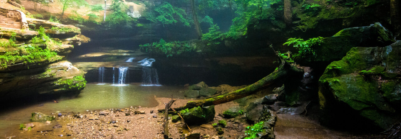
Manhabezo Falls
Located 25 miles from the Union Bay area, the Presque Isle area of Porcupine Mountains Wilderness State Park is like a whole different park. This section of the park is home to three waterfalls: Manabezho Falls, Manido Falls, and Nawadaha Falls. A moderate hike of about two and a quarter miles will take you to these three falls.
These picturesque falls are all on the Presque Isle River and the water flows from up in the Porcupine Mountains and it wears down the rocky bedrock as it travels into Lake Superior. As in the case of what is known as “the potholes”, the swirling water has cut half circles out of the rock and is really interesting to watch from above on the rope bridge.

Manido Falls
My one complaint about the area is that with all the foliage, the various falls can be difficult to see from the observation areas. You can’t even really see Nawadaha Falls on the parking lot side of the river. There are signs all over telling you to stay on the path and if they really want people to do that, they should trim the trees that block the views from the platforms (see the large leaf in the above photo of Manido Falls). If people see the falls from the viewing areas, they are much less likely to go off the path and do something unsafe to get that photo.
When you get to the Presque Isle section of the park, there are a few different parking areas so you don’t have to hike the full 2.3 miles to see these waterfalls. There are three different parking areas and the one closest to the ranger station allows for ADA accessible viewing of Nawadaha falls. The rest of the falls do require some stair climbing to get to view. This is one of the most accessible parts of the Porcupine Mountains because you don’t have to climb any mountains to see these waterfalls!
Thanks for stopping by! To read more about this trip, check out our Great Lakes – Great Summer Road Trip. To read about some of our previous trips, click here. If you like my photos be sure to “like” my Facebook Page, follow me on Instagram! You can purchase prints on Etsy and Fine Art America. To see inside my camera bag, check out my Gear Page. For information about our new Guided Photography Tours, visit GuidedPhoto.com.
Pin This:


The Lake of the Clouds overlook is the most famous view in the Porcupine Mountains and one of the most famous views in all of Michigan. It shouldn’t be surprising that Lake of the Clouds was our first stop after arriving at Michigan’s largest state park. This was my first time at Porcupine Mountains although Chris did a backpacking trip through the park in high school. It was nice to have a private tour guide on this visit!
The 60,000-acre park is home to 35,000 acres of old-growth forest and is one of few remaining wilderness areas in the midwest. There are 90 miles of hiking trails in the park as well as many opportunities for camping. There is a disc-golf course and in the winter it is a big skiing destination. Of course, photos I’ve seen of the park in fall are absolutely breathtaking.
 After checking out the iconic Lake of the Clouds view, we did a short evening hike on the Union Mine trail. At a little over a mile, the flat, interpretive trail is one of the easiest in the park. The trail takes you by remnants of the abandoned Union Mine, an abandoned copper mine. But, the biggest draw for this trail is its numerous small waterfalls (left). I’ve been told in the spring, the views on this trail are breathtaking! I was surprised to see these falls documented in my Michigan Waterfalls book when we got back to the car.
One thing to note about Porcupine Mountains Wilderness State Park is that it really is a wilderness. The ADA accessible Lake of the Clouds overlook is one of the only things to do in the park that doesn’t involve backcountry hiking with some steep elevation. If you are not in great shape, its a good idea to do some conditioning before heading to the park.
Thanks for stopping by! To read about some of our previous trips, click here. If you like my photos be sure to “like” my Facebook Page, follow me on Instagram! You can purchase prints on Etsy and Fine Art America. To see inside my camera bag, check out my Gear Page. For information about our new Guided Photography Tours, visit GuidedPhoto.com.
Pin This:


During our Epic Michigan Road Trip a few years ago, we spent the day driving from Houghton to Munising exploring Northern Michigan’s waterfalls. I had heard about Laughing Whitefish Falls and wanted to check it out. We looked it up on Google Maps and headed out to see it. Google suggested a shortcut so we took it. After driving a little while the road we were driving on turned into a two-track. We figured if it’s on Google its got to be a legitimate road so we continued driving. After bouncing around for a while we came to a creek running across the road. At the time we were driving our Kia Soul which is not much of an off-road vehicle and we didn’t think would be a good idea to drive our car through water, so we turned around and headed back where we came from.
 Ever since that day, I have seen pictures of these falls and I put them at the top of my list for things to see on a return trip to the UP. When planning this trip, I saw the drive from Fayette to the Porcupine Mountains as a perfect time to take a detour to Laughing Whitefish Falls. This time, we stuck to the main route and we made it!
Laughing Whitefish Falls is one of the tallest waterfalls in Michigan and is really impressive to see in person. The trail from the parking area to the falls is about a mile long and ends at a viewing platform at the top of the falls. From there you can take the very large staircase to get you to the bottom of the approximately 100-foot tall waterfall. Make sure you bring water because it is a lot easier to go down all those stairs than it is to go up them!
Laughing Whitefish Falls is located off of M-94 between Munising and Marquette near the town of Chatham. Be sure to follow the signs to the park and not follow GPS guidance unless you are prepared to go off-roading!
Thanks for stopping by! To read more about our UP adventure, check out the Great Lakes, Great Summer Road Trip Report. To read about some of our previous trips, click here. If you like my photos be sure to “like” my Facebook Page, follow me on Instagram! You can purchase prints on Etsy and Fine Art America. To see inside my camera bag, check out my Gear Page. For information about our new Guided Photography Tours, visit GuidedPhoto.com.
Pin This:


Me posing by a roadside waterfall
On our first trip to Acadia, our biggest disappointment was that we didn’t get a chance to explore the miles of Acadia’s carriage roads. Everything you read about Acadia tells you that you don’t really see the park until you see the carriage roads. So, on a day when we didn’t have anything planned, we rented some bikes and we set out to see the interior of the park.

Waterfall cascading to Jordan Pond from the carriage roads.
Since we were staying in Southwest Harbor, we decided to rent bikes from Southwest Cycle. The staff there were very friendly and helpful. They helped us pick the right bikes and get the bike rack on our rental car. If you are staying on the quietside, I highly recommend renting from Southwest Cycle.
After getting our bikes, we headed to the Carriage Roads. Honestly, I was not prepared for the beauty of the carriage roads. There were WAY less people than on the park loop road. It was cool to be able to look down on the Park Loop Road and the Jordan Pond Trail too! After our first trip, if you would have asked me if there were waterfalls in Acadia, I would’ve told you no. But, we saw several on our bike ride through the carriage roads.
 One thing I wasn’t prepared for was the difficulty of the carriage roads. They were all designed to be driven by carriages, so they weren’t mounting biking difficult, but there were some steep hills we had to climb. I am not an avid biker by any means, so I had to take a few breaks during our bike ride. I did enjoy coasting down the big hills, though! Some of the roads are easier than others, so I recommend if you’re a novice bikers like me that you plan a route that you can handle.
The quiet beauty of the carriage roads is something that you have to experience for yourself. Definitely take a day to explore them! If you aren’t a biker, you could pick some of the shorter ones and walk them or you can take a carriage tour, which I will talk about in a later post! You won’t regret getting away from the crowds and seeing the interior of the park!
Thanks for stopping by! To read about some of our previous trips, click here. If you like my photos be sure to “like” my Facebook Page, follow me on Instagram! You can purchase prints on Etsy and Fine Art America. To see inside my camera bag, check out my Gear Page. For information about our new Guided Photography Tours, visit GuidedPhoto.com.
Pin This: