Travel by Any Means Necessary

Tag: hiking Page 2 of 5

Sitka National Historic Park

Totem Pole Trail

After learning about bears and raptors, we headed to Sitka National Historic Park. The National Park Service Site is located a short walk from the Alaska Raptor Center. The park preserves the site of the battle between the Russian settlers and the native Tlingit people. The park was Federally protected back in 1890 and was the first federally preserved piece of land in Alaska.

Sitka was home to one of the first European settlements in Alaska being settled by Russian fur traders in 1799. In 1802, the native Tlingit destroyed the original settlement killing many of the settlers. In 1804 Russian forces returned and bombarded the Tlingit during a bloody battle that the Tlingit would have won had they not run out of gunpowder. Instead, they were forced to leave the fort under cover of darkness. The park sits on the site of this battle.

Yaadaas Crest Pole

One of the highlights of the park is the mile-long Totem Trail. The park is even known to some as the Totem Park. 18 Tlingit and Haida totems can be found along the trail conveying ancestry, history, folklore, and memorials. There are three main types of totem poles: house posts, which were carved as support poles for a home; frontal poles, which were placed against or near the front of a home; and detached poles which were placed anywere in or near villages. The Yaadaas Crest pole (left) was re-carved in 1982 and the figures on the pole represent the lineage of the family that owned it. The village watchman sits on top to symbolize that the people are being watched over and protected.

The totem pole featured at the top of the page is the K’alyaan Pole which represents the Battle of Sitka. The figure on the bottom of the pole represents the raven helmet of the Tlingit warrior who led the battle. The rest of the pole depicts the clans of the raven moiety. The pole was carved in 1999 and stands on the site of the Kiks.adi fort.

There is much more to see in this 112-acre park than we had time to explore. So, like many of the places we have been lately, Sitka is on our list of places fo us to return.

Thanks for stopping by! To learn more about the Sitka Historic Park and the significance of its Totem Poles, visit NPS.gov. To read more about this trip check out my Planes, Buses, and Boats Trip Report. To read about some of our previous trips, visit my Trips Page. If you like my photos be sure to “like” my Facebook Page and follow me on Instagram! You can purchase prints on Fine Art America. To see inside my camera bag, check out my updated Gear Page.

Pin This:

Totem Park Pin Sitka National Historic Park

Wordless Wednesday: La Coca Falls

La Coca Falls

Wordless Wednesday: El Yunque

El Yunque Mountains

Hiking El Yunque National Forest

El Yunque Vista

El Yunque National Forest in Puerto Rico is the only tropical rainforest in the U.S. National Forest system. El Yunque is located near Rio Grande and is a 35-minute drive from the San Juan area. El Yunque is one of the most popular attractions on the island. Just like many of the national parks we visited last summer, a $2 reservation is required to drive into the National Forest. Reservations can be made up to a month in advance at Recreation.gov.

Posing at La Coca Falls

Once you get into the national forest, there are several places to get out and explore. The first is La Coca Falls (left), which is a large waterfall right at the side of the road. With an 85 foot drop, La Coca Falls is a great introduction to the rainforest and a wonderful photo opportunity.

The next stop is Yokahu tower (right). Built in the 1960s, Yokahu tower offers a 360-degree view of the rainforest and the coastline. On a clear day, you can see all the way to the Virgin Islands. The forest service offers a concession stand in the tower and if you have a National Park passport, they have a stamp here.

Yokahu TowerWhen planning this trip, the La Mina Falls trail looked like one of the best, easier hikes in El Yunque, but unfortunately, it has not reopened after hurricane Maria. So, we decided to hike the Mt. Britton trail. When we visited, the road through the forest was closed at the picnic area, so that added an extra mile to this hike. According to the forest service’s Facebook page, the road should be closed farther down than it actually was when we visited. The roads through the forest are steep and winding and hiking on the road felt more difficult than the trail itself. If you are planning to hike the El Yunque or Mt. Britton trails, just be aware that the road closure adds additional mileage.

Mt. Britton TowerOnce on the trail, it was a beautiful trek through lush, tropical greenery. The trail is a 1.3 mile hike (0.8 miles each way) with 650 foot elevation gain. The forest service says this hike takes 45 minutes each way, but we went down much quicker than that! This is a steep hike so it can be tough on the knees. Make sure you have shoes with good traction as rain is frequent in the rainforest. The Mt. Britton tower (left) at the end of the trail, was built by the Civilian Conservation Corps in the late 1930s and offers beautiful views of Puerto Rico, The Caribbean, and the Atlantic. The view from the top (top) makes the climb worth it!

Mt. Britton Tower from Below

We climbed all the way to that tower!

If you are staying in Puerto Rico for any length of time, you definitely have to check out El Yunque! With the current road construction, the forest service is limiting reservations even more. If you are unable to get a reservation, there are many tour companies that take visitors to El Yunque.

Thanks for stopping by! To read more about this trip check out my Island a Day Trip Report. To read about some of our previous trips, visit my Trips Page. If you like my photos be sure to “like” my Facebook Page and follow me on Instagram! You can purchase prints on Fine Art America. To see inside my camera bag, check out my updated Gear Page.

Pin This:

Hiking El Yunque Pin El Yunque Pin

Exploring Theodore Roosevelt National Park

CCC Pavilion in Theodore Roosevelt National ParkLocating in northwestern North Dakota, Theodore Roosevelt National Park is one of the least visited National Parks in the United States. It averages about 600,000 visitors a year which might sound like a lot, but if you compare it to the 4 million that visit Yellowstone or Yosemite each year, 600,000 is not much at all. Coming from Glacier (which averages about 3 million visitors), the difference is very noticeable.

We started our exploration of Theodore Roosevelt in the North Unit which was closer to where we were staying. Of the two main units, the South Unit gets most of the traffic so when we arrived in the evening, we only saw a handful of other cars in the whole north unit. The north unit has a 14-mile one-way scenic drive that showcases the unique geological features of the park. There was plenty of parking at each of the overlooks and fresh air to breathe.

The South Unit of the park is larger than the north and is much busier. The South Unit has a 36 mile scenic loop drive that allows you to see the highlights of the park. Four miles of the road is closed indefinitely due to a landslide, although the area is open to hikers and bicyclists. Right where you have to turn around for the road closure there was one of the biggest prairie dog towns we saw on the trip.

Bison of Theodore Roosevelt National Park

Wildlife is the highlight of a trip to Theodore Roosevelt. Muledeer, antelope, bighorn sheep, wild horses, bison, and prairie dogs can easily be seen in the park. When we were in the Black Hills we were SO excited to see a bison. By the end of our week in North Dakota, we were begging them to get out of the road so we could go home!

We had planned to do some hiking during our time at Theodore Roosevelt but with heat spell that was going on this summer, we determined it wouldn’t be safe. One day we stayed at the park until the sun went down and the temperature didn’t get below 90. Theodore Roosevelt National Park is on our list to return to outside of the summer or when Chris isn’t working so we would be able to hit the trails before the heat of the day.

If you are looking to visit a national park and get away from the crowds, definitely head to Theodore Roosevelt National Park, especially the North Unit. If I were to do this trip again, I would shorten the amount of time we had here, though. Unless you are doing a lot of hiking, you can see this whole park in two to three days.

Thanks for stopping by! Be sure to check back next week when I detail our experience at the Elkhorn Ranch Unit. To read more about this trip, check out the Epic National Park Road Trip. To read about some of our previous trips, visit my Trips Page. If you like my photos be sure to “like” my Facebook Page and follow me on Instagram! You can purchase prints on Fine Art America. To see inside my camera bag, check out my updated Gear Page.

Glacier National Park: Exploring Many Glacier

Swiftcurrent Creek

In the summer of 2021 Glacier National Park, instituted a reservation requirement to drive the ever-popular Going-t0-the-Sun Road during the day. These reservations were very difficult to get and many people chose to postpone their trips to Glacier. Those that did not were able to get to the road early in the morning or in the evenings. Another option was to explore the other areas of the park that are not on Going-to-the-Sun Road. One of these areas is the Many Glacier area.

This area is home to the picturesque Many Glacier Hotel. At the base of a mountain on Swiftcurrent Lake, this is where I want to stay on my return trip to Glacier. The hotel is also the base for one of the park’s boat tours. The boat ride across Swiftcurrent Lake can help cut some mileage off of one of the longer hikes.

Dock on Swiftcurrent Lake

Many Glacier is the jumping-off point for one of the more popular hikes in the park, The Grinnel Glacier Trail. The 7.6 Mile (although boat rides can shave off 3.4 miles) round trip hike gains 1840 feet in elevation and gets you a view of the 152 acre glacier, one of the largest left in the park. When we visited at the end of June, most of the trail was still snow-covered and rangers were in the parking lot, dissuading people from embarking on the hike.

Unfortunately, road construction on Many Glacier Road left us with much less time to explore this part of the park than we had originally hoped. We ended up just walking the Swiftcurrent Nature Trail around the lake before heading back to the car so we could make our reservation for the boat tour in the Two Medicine area of the park. Because of our limited time in Many Glacier, I definitely want to return and maybe try my hand at the Grinnel Glacier hike.

Since this is one of the areas of the park that didn’t require a reservation this year, the small parking areas filled up early in the day. I was hoping the road construction would keep people away but that did not appear to be the case at all. If you plan on exploring the Many Glacier area, plan to get there early to make sure you have a place to park.

Thanks for stopping by! Be sure to stop by next week as we explore the Two Medicine area of Glacier National Park! To read more about this trip, check out the Epic National Park Road Trip. To read about some of our previous trips, visit my Trips Page. If you like my photos be sure to “like” my Facebook Page and follow me on Instagram! You can purchase prints on Etsy and Fine Art America. To see inside my camera bag, check out my updated Gear Page.

Pin This:

Many Glacier Pin

Yellowstone: Mammoth and Canyon in One Day

Mammoth Hot Springs

Steam coming off Mammoth Hot Springs

This post contains a lot of information about driving around Yellowstone. Here is a link to a map of the park, that will probably be a helpful reference while you read about our first day in Yellowstone.

Our first day in Yellowstone, we came into the park from Cody. I really believe this played a hand in our ability to see so much of the park in just one day. Unlike the west entrance, there was no line coming in from the east side of the park. The first point of interest coming in this way is Yellowstone Lake and the Fishing Bridge area. This is one of the lesser-visited parts of the park and it felt like we were the only people around for miles.

Clouds over Yellowstone Lake

Yellowstone Lake (above) is a sight to behold. Situated at 7700 feet above sea level and taking up 132 square miles, Yellowstone Lake is the largest high elevation lake in North America. Because of the large surface area, sudden gusts of wind can create large waves making open water crossings of the lake very challenging. Because of that and the cold water temperatures, boating on Yellowstone Lake is not incredibly common.

Grand Canyon of the Yellowstone
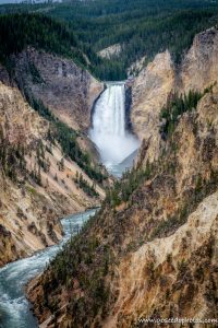
From Fishing Bridge, we headed north to Canyon Village and one of my must-sees, Grand Canyon of the Yellowstone. There is a very large parking area in the canyon area and we had no trouble finding a spot to park.  One of the best views of the falls can be found at the Artist Point trailhead (left). I love how even unedited photos of the waterfall look like a watercolor painting. This is one of the most popular areas to hike in the park with plenty of hiking trails for all abilities. For more information about hiking in Yellowstone, visit NPS.gov.

The color of the rock makes The Grand Canyon of the Yellowstone one of the most unique waterfalls I have ever seen. At one time a geyser basin was located at what is now the base of the waterfall. The heat and chemical activity of those geysers created rhyolite, a soft and brittle rock. The rhyolite reacts to oxygen in the air and in effect, the canyon walls are rusting, which gives it that unique yellow color.

From Canyon, we headed toward Mammoth. The drive through that part of the park felt longer than going from Lake to Canyon, but maybe it was just that there isn’t anything to stop and see from Norris to Mammoth. I’m not sure if this is normally the route you would take to get from one area to another, but the road from Tower/Roosevelt to Canyon was closed for construction in 2021.

Mammoth Hot Springs

Mammoth Hot Springs (top and right) was another feature on my Yellowstone Must-See list. I had seen photos of the unique, stair-like geothermal feature and wanted to see it for myself. The water in the springs container calcium carbonate that over time cools and creates these unique rock formations. It was interesting walking around and seeing how the pools have shifted over time, as evidenced by forests of dead trees with white, calcified bases.

Bear and Two Cubs

From Mammoth, we headed to Tower/Roosevelt and this is where we encountered our biggest “jam” of our time in the park. This time, instead of elk, it was a mother bear with two cubs (viewed from a safe distance, of course, and with a ranger standing by with bear spray). It was super cool to see these wild animals through a zoom lens. It was definitely better than seeing them at the zoo!

After our bear encounter, we headed out the Northwest Entrance of the park to Gardiner for dinner. Be sure to stop back next week as I share about our day of exploring geysers and hot springs!

Thanks for stopping by! To read more about this trip, check out the Epic National Park Road Trip. To read about some of our previous trips, visit my Trips Page. If you like my photos be sure to “like” my Facebook Page and follow me on Instagram! You can purchase prints on Etsy and Fine Art America. To see inside my camera bag, check out my updated Gear Page.

Pin This:

Mammoth Hot SpringsPinterest Graphic Grand Canyon of the Yellowstone Pinterest Graphic

Devils Tower National Monument

Devils Tower

Devils Tower National Monument is located in the northeastern corner of Wyoming, only about an hour and a half away from Rapid City, South Dakota. Signed into law by Theodore Roosevelt on September 25, 1906, Devils Tower was the first National Monument in the world. The monument is a popular place for rock climbers as well as hikers and others who just want to see this unique geological feature for themselves.

When planning this trip, I originally wanted to visit Devils Tower on the way from Custer to Yellowstone, which would’ve had us arrive mid-morning on a Saturday. Then, I learned that the parking lot fills up early, especially on weekends, and it is not uncommon to have to wait a while for a spot. Since we had quite a bit of ground to cover that day, I decided it would make more sense to make it a day trip from the Black Hills, and that way we could also see Spearfish Canyon on the way back.

We left Custer after Chris got off work and arrived at Devils Tower around 5 pm. There were only a handful of people around and we had no trouble parking. The visitor center closes at 6 but I was happy to see that the passport stamp is outside so that if you arrived when the visitor center was closed, you would still be able to get a stamp. Because we wanted to see Spearfish Canyon before sunset, we didn’t have much time to explore the monument, but we did get to walk a little bit of the Tower Trail.

Roughlock FallsSince this was our last day in the Black Hills, I may have tried to cram too much in, especially with the three-hour round trip drive to Devils Tower. But, we did enjoy the GyPSy tour of the Northern Black Hills and the drive through Spearfish Canyon. The Spearfish Canyon Scenic Byway is a beautiful drive that follows a river that has cut through these high rock walls. Spearfish Canyon is an absolutely beautiful area that just blew me away! There are several places along the way to stop and enjoy the beauty of the canyon. We got out and stretched our legs at Roughlock Falls (left). Several scenes from Dances with Wolves were filmed in this area and maybe recognizable to fans of the film. We had planned to checkout Deadwood this day, but the road was closed for a parade or something so we just kept driving. I guess we will just have to come back with more time to explore the Black Hills!

Thanks for stopping by! To read more about this trip, check out the Epic National Park Road Trip. To read about some of our previous trips, visit my Trips Page. If you like my photos be sure to “like” my Facebook Page and follow me on Instagram! You can purchase prints on Etsy and Fine Art America. To see inside my camera bag, check out my updated Gear Page.

Pin This:

Hiking Balcones Canyonlands

The view of the Colorado River from Warbler Vista
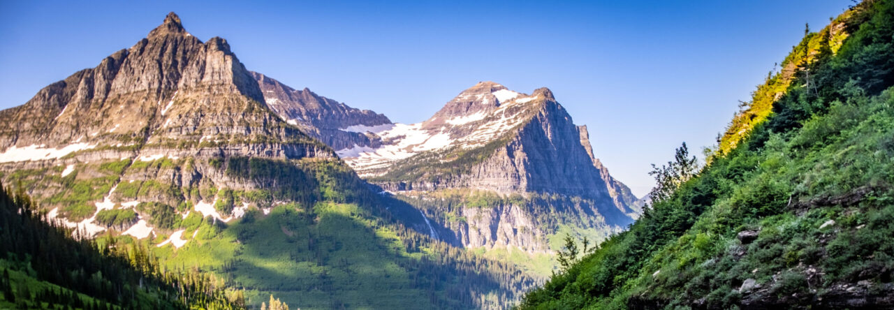
The drive from Fredericksburg back to Austin was the longest driving day of our Hill Country Road Trip. In terms of some of the road trips we’ve taken, an hour and forty-five minutes drive are not that bad, but it doesn’t hurt to get out of the car and stretch your legs and take in some natural beauty.

To stretch our legs on this day, we decided to stop at Balcones Canyonlands National Wildlife Refuge. Located near Marble Falls, Balcones is about an hour drive from Austin and would be a good place to get away from the city and get into nature. As a National Wildlife Refuge, this area is popular with birders. We stopped at the Warbler Vista section of the park which offers three fairly short trails to explore. If it’s not obvious by the name, this area is prime warbler habitat.

Trail through trees

We started our visit at the end of the road at the sunset viewing platform (above). This overlook gives a view of the Hill Country as well as Lake Travis. After taking in the view and enjoying the (once again) warm Texas sunshine, we embarked on the 1.25 mile Cactus Rocks loop trail. We began on the northern branch of the trail which was significantly flatter and easier than the southern portion which had more elevation change. Overall, the trail was a pretty easy hike in the Texas wilderness. If you are looking to escape the city and get back into nature on a trip to Austin or just a place to stop between Fredericksburg and Austin, this park is quiet and off the beaten path.

Thanks for stopping by! To read more about this trip, check out the Texas Hill Country Road Trip Report. To read about some of our previous trips, visit my Trips Page. If you like my photos be sure to “like” my Facebook Page and follow me on Instagram! You can purchase prints on Etsy and Fine Art America. To see inside my camera bag, check out my updated Gear Page.

Wordless Wednesday: Grapes on the Vine

Page 2 of 5

Powered by WordPress & Theme by Anders Norén